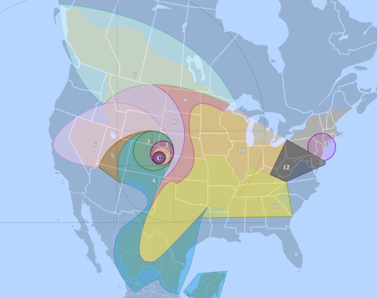
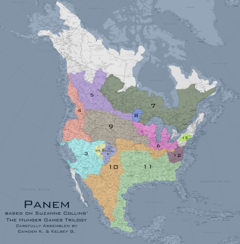
Bloggers aimmyarrowshigh and badguys have created this exceptionally accurate map of Panem, the world created by Suzanne Collins in her series “The Hunger Games“. Panem is described being a North America that has been ravaged by war and geological catastrophes.
“The result was Panem, a shining capitol ringed by thirteen districts, which brought peace and prosperity to its citizens. Then came the Dark Days, the uprising of the districts against the Capitol. Twelve were defeated, the thirteenth obliterated.”
 image courtesy of badguys and aimmyarrowshigh
Click the map. It’s massive. And well thought out. Its creators took into consideration all sorts of information from the books, including:
- The Capitol is in Denver.
- D12 is Appalachia.
- D11 shares a border with D12, is one of the largest districts, is South of D12, and is primarily used for growing grain and produce.
- D10 is primarily used for raising livestock. They do NOT process the livestock in D10. However, to feed an entire nation, D10 is likely another very large District.
- D9 processes food for the Capitol and the tesserae; therefore, it likely shares borders with the food production Districts (D4, D10, D11).
- D8 produces and treats textiles and is a factory District. It is POSSIBLE to reach D12 from D8 on foot over a course of weeks/months. Therefore, it does not cross a large body of water.
- D7 specializes in lumber. It’s probably large. It has no role in food processing or manufacture.
- D6 works closely with the Capitol in the research and manufacture of drugs (morphling, medicines). It likely has close ties to D5 in the production of mutts.
- D5 is entirely dependent on the Capitol, so it’s probably somewhat nearby, and specializes in genetic research and manipulation. Because of the necessity of creative thought and intellect, it’s most likely a smaller District so that it’s easier to monitor and control.
- D4 is the ocean. It does have a role in food production. It’s very large. It is a Career District, so it likely is near the Capitol and has some self-sufficiency, but not enough that it doesn’t engender loyalty. (Aside from that, D4 = perfect.)
- D3 has extremely close ties to the Capitol and works with electronics and technology. It is likely small, the Capitol can closely monitor its scientific minds. It has no role in food manufacture or processing.
- D2 specializes in weaponry, is the most loyal District (because the Capitol needs to keep its weapon specialists happy, non?), and has no role in food production. D2 also works in some minor Mining elements and trains Peacekeepers. The Panem railroad is easily accessible in D2.
- D1 produces luxury goods for the Capitol — INCLUDING having a diamond mine. Kelsey Lake Diamond Mine is a defunct diamond mine in Colorado, USA. It is located in the State Line Kimberlite District, near the Wyoming border.
- D13 specialized in nuclear power, shares a border with D12, is both visible and reachable from D12 by foot, and is North of West Virginia. Three Mile Island was in New York Pennsylvania, and probably remained a nuclear reactor or was co-opted again as a reactor. D13 is small but mighty and is surrounded by Wilderness. It is self-sufficient.
This information was combined with some speculation about the results of future cataclysmic natural disaster in order to reach the maps final result. Of course, to me, the most interesting aspect of the map is the Capitol is located in what is now Denver, Colorado. I like the idea of Denver being the future capital of the post-apocalyptic dystopia.
Additionally, I would be remiss to not include Nerd Friday’s version of the Panem map shown below. This arguably more accurate map places the Capitol near Grand Junction, Colorado. More information about Nerd Friday’s creation process can be found in the bibliography and referenced works as well as the frequently asked questions section.


District 2 was very big it said in book 3
The capital could not be Denver unless the geography changed a great deal. Denver sits on the High Plains, and is not ringed by mountains as the book describes. I am a Denver native.
Totally agree even if the Capitol included Boulder there is still a gap between the flat irons and the surrounding mountains #gobuffs
how did it all get this way? what’s happening with all of the rest of the world? are there other nations out there? i tried to come up with reasons for why these other nations haven’t interfered or attacked my best guess is they’ve been waiting for a revolution for an easy conquest. i’m guessing theres going to be a prequel.
Many possible theories it may be that after all the catastrophes other nations left have no form of communication with each other. Other pockets of land woild be very distant (South America, Central and Sub Sahara Africa, and Central Asia). Most likely these countries will try to focus on internal affairs. Or perhaps Panem is like North Korea where it’s inhabitants are unaware of the outside world (if not all the other natioms have their citizens umaware of other lands). What would be interesting is to have the canon expanded. Have a sequel where forces from the outside collide (or at least interact) with Panem. Or have a successor to Snow escape during the capitualation of the Capitol and has created allies and amassed an invasion from outside of Panem. I don’t know. Just my thoughts.
Maybe the capitol wants to separate the districts from the outside world, therefor they use a forcefield like in the arenas
also i think the size of it all is too big everything in district 12 seems to be in walking distance and in these maps depict 12 being a 3 hour DRIVE from edge to edge
It say in mockingjay on page 260 line 16 that the Capitol forms an almost perfect square so neither map is right
Basically your saying that instead of just Denver or even the surrounding towns the Capitol is the WHOLE 836×578 miles of Colorado think the math is right there correct me if it isn’t
I remember in the books it mentioned that D12 was somewhere by the Rockies.
In the wiki, which may possibly be based on the film, it mentions District 1 having a machine that creates diamonds from graphite. This could mean that 1 doesn’t necessarily have a diamond mine, unless it mentions in the books that it does, I can’t remember.
The Capitol is square, and surrounded by mountains. So, It must be in Utah. And District 2 is MUCH larger
I don’t remember which book, but Katniss describes D12 being both the poorest and smallest district. Both of theses maps have D1 being the smallest not D12.
She could mean smallest in population… Would you call NYC a “small” city?
I’m not understanding why these districts are touching. I see that you’re trying to ‘fill up’ the map, but in all likelihood there are vast amounts of wilderness between each district. Otherwise there would be NO way for Bonnie and Twill to get to the woods outside 12 without crossing the monitored land in another district. And where are you getting the info that 12 can be seen from 13? It’s a 45 minute trip by hovercraft, so it’s not exactly next door.
Also, space for Hunger Games arena sites are completely missing. The Games don’t take place in a district or the capitol, and they become historic sites once the Games are over.
Maybe they use Canada for the Arenas cause I think Panem is all of North America, and the space i don’t think would be used for anything else
My husband just compared me to Joanna. Come on, right? I mean RIGHT? AND this was after I said that he’s like Gale (though he’s really like Peta).
Isn’t it implied that since District 10 and District 4 have similar wedding customs that they should be very close to each other? It only makes sense to me because that is how the Districts would get information before the dark days, close borders mean some overlapping of customs.
In the books, it clearly states that the districts don’t border each other, rather have a spacious gap between them. I’m an Australian and I know that these maps aren’t right.